|
|
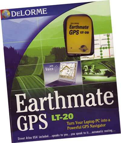
Where am I? Handheld GPS Devicesby Guy Serbin, PhD and Richard Serbin Preface. If you’ve never been lost, skip this review. Otherwise, read on. I’ve asked the Serbin family (international business travelers) to review two units. One, the first, helps you locate specific addresses and locations and is primarily for urban navigation. The second device is specifically for outdoor and leisure users. There are no detailed maps with the unit reviewed, although they can be purchased. If you are a biker (non-motorized type), or hunter, or simply want to navigate through a metropolitan area to get to some other place, chose this one. One note. Most of the less expensive models use batteries. More expensive units use a rechargeable battery. You’d think this is a no-brainer, but if you are out hunting in the forest and your rechargeable battery goes out, then disposable batteries might be a better alternative. I’ve not seen a tree yet that had a 115 volt outlet! All of these units and their siblings typically have updates, especially firmware updates. Go to their web site and download them before leaving. Frequently, there are rebates available. Enjoy. DeLorme Earthmate GPS Receiver LT-20 & Street Atlas 2005
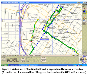
As Street Atlas USA is updated every year, I checked subsequent editions to see if his street showed up. After it didn't appear for several years, I gave up. DeLorme is not alone in this flaw. My wife's Honda Odyssey has a $2000 navigation system with maps that, among other shortcomings, don't have portions of streets which have been there for decades and I'm not talking about backwater cart ways; the case in point is a four lane concrete street with a grass median that is a major Interstate exit. I am pleased to report that now, a decade later, his street appears in Street Atlas USA 2005. Furthermore, the software does allow for missing streets to be added using features in the Draw tab, which allowed us to add in a missing section of University Blvd. between South Main and Fannin Street in the Texas Medical Center. However, we found no easy way to add additional information to this section (such as street name, addresses, etc.). Unfortunately, that is about the only good news I can report about this software. If we were unfamiliar with University Blvd. and were relying upon Street Atlas USA 2005 to get us to a destination on the missing section of University Blvd., we'd be up the proverbial tributary without sufficient means of propulsion. Street Atlas USA 2005 is far less user-friendly than I remember the original version to be and I would describe it as not intuitive – in fact I think the term "obtuse" could easily apply. Mapquest and MSN Maps are far easier to use. As just one example, whereas Mapquest and MSN Maps give you separate fields for street address, city, state, and zip code, Street Atlas USA 2005 gives you one field for the entire address leaving one to wonder in what format it wants the input. Other notable features of this software include the ability to look up and locate "Points of Interest." These include restaurants, but what I find curious is that it identifies obscure restaurants but does not identify some well known, high-volume restaurants. Furthermore, not included in the detailed information about a location is its address, which after all, is the point of the whole exercise and I find curiouser and curiouser. The streets on the map are often crooked and misaligned when, in fact, they are dead straight. I surmise that this is because it comes on a CD instead of a DVD and this necessitates a very aggressive compression algorithm. At this late date in the evolution of computers, a DVD version should be included which would allow for more information and a less aggressive compression algorithm. There were a few technical issues that we saw with the GPS unit. For one, it was unable to locate itself until it had been stationary for at least a minute, so it is best to start the software and the GPS unit prior to going anywhere. Also, the unit performed poorly in downtown Houston, where the GPS often placed us up to two and a half blocks away from our actual location. In one case, when we were at a major intersection, it placed us over 1000 feet away as illustrated in Figure 1. Also, we would frequently lose GPS signals underneath overpasses, which is to be expected. GPS units work best when they have a clear view of the sky, and don’t have to deal with tall buildings or other aboveground objects that can reflect and obscure GPS signals. In most Houston locations, the GPS unit was more or less accurate when interference with the reception of satellite acquisition was not a factor. The Earthmate LT-20 can acquire up to 12 satellites. The more satellites acquired, the more accurate the location. As to the Earthmate GPS receiver, it is about a third the size of my original Earthmate. The good news is that DeLorme says that it can be used with other mapping software. We did not have any other software to test that claim. By the time you read this review, the newer edition will be out with 2006 street atlas. You can replay your route. Intriguing is the Voice Command option where you can ask your laptop PC directional questions.
The list price for this package (Street Atlas USA 2005 and the Earthmate LT-20 receiver) is $99.95 but rebates are common. I can give it a qualified recommendation. For more info and updates go towww.delorme.com. eXplorist 300 Handheld GPG Receiver by Magellan I've never used a handheld GPS device in the field before, but there were times hiking in England when I sure could've used one. For instance, we were hiking in the Lake District in England when a heavy fog closed in on us. We couldn't see more than 6' in any direction and multiple paths, often at small angles, kept crisscrossing, thus presenting a plethora of confusing options. Using a compass, topographic maps and sheer luck, we were able to emerge from the fog on course, but the result could have been very different and hikers in similar circumstances have died of exposure. A handheld GPS device would have made the hike much less stressful (and less dangerous) but in those days, handheld GPS devices were unavailable. Handhelds such as the eXplorist 300 are of limited value without good topographic maps that among other information, give you coordinates and together with a handheld GPS can tell you where you are. In the above case, merely using waypoints to backtrack would not have been an attractive option as daylight was fading and there was not sufficient time to backtrack before nightfall. The 300 is the top of the range in the eXplorist non-computer programmable series. The screen, however, is still black & white. Color would be much easier to read, particularly in low light situations. Several features I do like however are: the Barometer and Thermometer, the Electronic compass and particularly, the Barometric Pressure Altimeter. The 300 allows you to view speed, direction, distance to destination and the status of the GPS satellites which it is receiving signals from. The maps supplied with the 300 are minimal even for Houston, Harris County, Texas, the 4th largest city in the United States. All that are shown are freeways and a few major thoroughfares, so it is not very useful for navigating through the neighborhood. This shortcoming can be cured by upgrading to an eXplorist 400, 500 or 600, which are capable of receiving map downloads from a computer. The eXplorist line consists of six different models that, in my opinion, could have been cut to two or three at the most. At $400 (local discount price), the 500 should include a few nice features that are present on the eXplorist 600 for $50 more (3-axis electronic compass, Barometric pressure altimeter, barometer, and thermometer, all of which come with the 300) – or just eliminate the 400 and 500 altogether and sell only the 600 ($50 more locally). Both the Magellan documentation and website are incomplete and confusing. Both tell you that the units are capable of certain features, but don't tell you how to use them. An inquiry I sent to Magellan Customer Service over four days ago has been answered only by an e-mail stating that my inquiry would be passed “to the appropriate group within Thales Navigation.” With such poor documentation, I do not expect a reply any time soon. Their tech support people must be very busy. Unless you are using a model that accepts memory cards or computer downloads, these units are not like Street Atlas by DeLorme that runs on a computer or the automobile navigation systems you may be familiar with. There is no street level mapping on the eXplorist 300. If you want it to tell you how to get to a given address, you need a more sophisticated unit. If you have latitude and longitude coordinates for your destination, you can input this and it will show you how close you are but not what streets to take to get to your destination. In practical terms, it is highly unlikely that you would have the latitude and longitude of a street address. Consider this a tool primarily for the outdoorsman who has topo maps. This unit is great for trekking, biking, hunting, etc. where specific locations are unimportant. Irrespective of its disadvantages, it does, however, do a decent job of telling you where you are, and can be set to English or Metric units, and a myriad of map projection and coordinate systems (i.e., LAT/LON, UTM, etc.). In our opinion, this unit would be fine if you’re just interested in a navigational aid in the backcountry in conjunction with topographic maps, so don't dispose of your paper topo maps just yet, unless you are prepared to spring for a computer downloadable model. For more info and updates go towww.magellangps.com. Richard Serbin is a HAL-PC member and Guy Serbin, PhD who is a family member, can be contacted at txcomb@hal-pc.org. |
2005
Nov/Dec Charles W. Evans is a HAL-PC member and the Magazine’s Reviews Editor who can be contacted at reviews@hal-pc.org |

 I owned the original version of the DeLorme Earthmate GPS receiver and Street Atlas USA perhaps a decade ago. It worked well
back then and was reasonably easy to use on my first color screen laptop. One of that version's shortcomings was that the maps were not up-to-date. As an example, I used a friend's
address in an adjacent city as a test case. He has lived there for five years. Nonetheless, his street (in fact the entire subdivision) did not appear on the map.
I owned the original version of the DeLorme Earthmate GPS receiver and Street Atlas USA perhaps a decade ago. It worked well
back then and was reasonably easy to use on my first color screen laptop. One of that version's shortcomings was that the maps were not up-to-date. As an example, I used a friend's
address in an adjacent city as a test case. He has lived there for five years. Nonetheless, his street (in fact the entire subdivision) did not appear on the map.